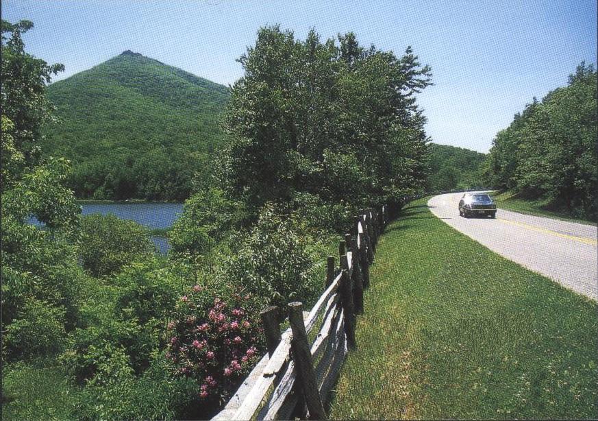
Sharp Top Mountain and the Peaks of Otter, which
are three mountain peaks (Sharp Top,
 Flat
Top and Harkening Hill) with man-made Abbott Lake lying in the valley between
the three peaks. Sharp Top, one of Virginia's famous twin peaks,
elevation 3,875 feet, has been a popular spot to see spectacular views of the
Blue Ridge Mountains since the days of Thomas Jefferson. Most of our mountains
are long ridges that stretch on for miles with no easily discernable or
precisely defined summit. Sharp Top is a roughly cone shaped massif that tapers
upward to a singular point, just the way you drew a mountain as a child. It's so
perfectly shaped, I guess we can excuse our Founding Fathers for thinking this
was the tallest mountain in Virginia. Sharp Top was long thought to be
Virginia's tallest mountain, when in fact, it is not even the tallest of "The
Peaks of Otter," which is formed by the triangulation of the three. Nearby Flat Top rises to 4,001 feet,
while Harkening Hill apex reaches 3,372 feet, and of course Mount Rogers near the
North Carolina border is Virginia state's tallest mountain at 5,729. Seven trails meander throughout this recreational area, traversing old-growth
hardwood forests, open meadows, rocky outcrops, a cascading waterfall,
streamside woodlands, and lake habitats. Today a shuttle
bus follows an old carriage trail to the top. Starting at trailhead you can take
an awesome hike up a mile and a half trail to the top of Sharp Top that has a
shelter at the peak and enjoy an unbelievable view of the the Blue Ridge Range
from this observation point. This is a rather rocky steep accent, and a little
more than a mile, the trail splits at the ridgeline, with the right fork leading
to Buzzard Roost (a rock formation with stunting vista). The left trail
heads straight for the summit, it continues another quarter-mile, climbing
steeply through and around bluffs and huge rocks. They have added stone steps
and railing to the last and steepest of the accent, to finally reaching the very
sharp top of Sharp Top, which provides a 360-degree view over the Blue Ridge
Mountains. The Piedmont to the east (Bedford and even Lynchburg are visible on
clear days) and the Shenandoah Valley to the west, with the Allegheny Mountains
and West Virginia far to the west. You have hiked 1,340 feet vertically from the
2,535 feet elevation trailhead (parking lot) to the summit. This is a must do thing,
breath-taking views, looking out over the expanse of the Piedmont and Shenandoah
valley and to the west seeing multiple waves of ranges, its easy to understand
why early settlers where fooled. The summit is mostly exposed granite boulders.
A sign reads: "That the Virginia stone in the Washington Monument come from
Otter's summit." Make sure you take another trail back down to Buzzard's
Roost and view the range looking back toward Sharp Top Mountain. Senior
citizens can use a paved golf cart trail that goes very near the top. The
above picture is Sharp Top, view from milepost 86 on the Blue Ridge Parkway which also
allows beautiful views of Peaks of Otter, milepost 84 - 87. The Peaks of
Otter Lodge and Restaurant, located at milepost 86 on the Blue Ridge Parkway
near Bedford, Virginia and open year round is a must visit, you won't be
disappointed. Locals brag about their Sunday morning breakfast. Here is a
link to
Harkening Hill and click on the pictures,
also viewing Sharp Top from the Peaks of
Otter Lodge. View Pictures of
Sharp Top You
may have hear the tragic story about 5 brave young Army airmen dying on a cold
February 2, 1943 night when their B-25 "Billy Mitchell"
bomber crashed into the
Southwest slope of Sharp Top Mountain. Some of the wreckage remains there from
that fatal WWII training navigation mission. Visit Bedford Museum.
Flat
Top and Harkening Hill) with man-made Abbott Lake lying in the valley between
the three peaks. Sharp Top, one of Virginia's famous twin peaks,
elevation 3,875 feet, has been a popular spot to see spectacular views of the
Blue Ridge Mountains since the days of Thomas Jefferson. Most of our mountains
are long ridges that stretch on for miles with no easily discernable or
precisely defined summit. Sharp Top is a roughly cone shaped massif that tapers
upward to a singular point, just the way you drew a mountain as a child. It's so
perfectly shaped, I guess we can excuse our Founding Fathers for thinking this
was the tallest mountain in Virginia. Sharp Top was long thought to be
Virginia's tallest mountain, when in fact, it is not even the tallest of "The
Peaks of Otter," which is formed by the triangulation of the three. Nearby Flat Top rises to 4,001 feet,
while Harkening Hill apex reaches 3,372 feet, and of course Mount Rogers near the
North Carolina border is Virginia state's tallest mountain at 5,729. Seven trails meander throughout this recreational area, traversing old-growth
hardwood forests, open meadows, rocky outcrops, a cascading waterfall,
streamside woodlands, and lake habitats. Today a shuttle
bus follows an old carriage trail to the top. Starting at trailhead you can take
an awesome hike up a mile and a half trail to the top of Sharp Top that has a
shelter at the peak and enjoy an unbelievable view of the the Blue Ridge Range
from this observation point. This is a rather rocky steep accent, and a little
more than a mile, the trail splits at the ridgeline, with the right fork leading
to Buzzard Roost (a rock formation with stunting vista). The left trail
heads straight for the summit, it continues another quarter-mile, climbing
steeply through and around bluffs and huge rocks. They have added stone steps
and railing to the last and steepest of the accent, to finally reaching the very
sharp top of Sharp Top, which provides a 360-degree view over the Blue Ridge
Mountains. The Piedmont to the east (Bedford and even Lynchburg are visible on
clear days) and the Shenandoah Valley to the west, with the Allegheny Mountains
and West Virginia far to the west. You have hiked 1,340 feet vertically from the
2,535 feet elevation trailhead (parking lot) to the summit. This is a must do thing,
breath-taking views, looking out over the expanse of the Piedmont and Shenandoah
valley and to the west seeing multiple waves of ranges, its easy to understand
why early settlers where fooled. The summit is mostly exposed granite boulders.
A sign reads: "That the Virginia stone in the Washington Monument come from
Otter's summit." Make sure you take another trail back down to Buzzard's
Roost and view the range looking back toward Sharp Top Mountain. Senior
citizens can use a paved golf cart trail that goes very near the top. The
above picture is Sharp Top, view from milepost 86 on the Blue Ridge Parkway which also
allows beautiful views of Peaks of Otter, milepost 84 - 87. The Peaks of
Otter Lodge and Restaurant, located at milepost 86 on the Blue Ridge Parkway
near Bedford, Virginia and open year round is a must visit, you won't be
disappointed. Locals brag about their Sunday morning breakfast. Here is a
link to
Harkening Hill and click on the pictures,
also viewing Sharp Top from the Peaks of
Otter Lodge. View Pictures of
Sharp Top You
may have hear the tragic story about 5 brave young Army airmen dying on a cold
February 2, 1943 night when their B-25 "Billy Mitchell"
bomber crashed into the
Southwest slope of Sharp Top Mountain. Some of the wreckage remains there from
that fatal WWII training navigation mission. Visit Bedford Museum.
2009 VA Open
| 2009 Tournament Dates
 Flat
Top and Harkening Hill) with man-made Abbott Lake lying in the valley between
the three peaks. Sharp Top, one of Virginia's famous twin peaks,
elevation 3,875 feet, has been a popular spot to see spectacular views of the
Blue Ridge Mountains since the days of Thomas Jefferson. Most of our mountains
are long ridges that stretch on for miles with no easily discernable or
precisely defined summit. Sharp Top is a roughly cone shaped massif that tapers
upward to a singular point, just the way you drew a mountain as a child. It's so
perfectly shaped, I guess we can excuse our Founding Fathers for thinking this
was the tallest mountain in Virginia. Sharp Top was long thought to be
Virginia's tallest mountain, when in fact, it is not even the tallest of "The
Peaks of Otter," which is formed by the triangulation of the three. Nearby Flat Top rises to 4,001 feet,
while Harkening Hill apex reaches 3,372 feet, and of course Mount Rogers near the
North Carolina border is Virginia state's tallest mountain at 5,729. Seven trails meander throughout this recreational area, traversing old-growth
hardwood forests, open meadows, rocky outcrops, a cascading waterfall,
streamside woodlands, and lake habitats. Today a shuttle
bus follows an old carriage trail to the top. Starting at trailhead you can take
an awesome hike up a mile and a half trail to the top of Sharp Top that has a
shelter at the peak and enjoy an unbelievable view of the the Blue Ridge Range
from this observation point. This is a rather rocky steep accent, and a little
more than a mile, the trail splits at the ridgeline, with the right fork leading
to Buzzard Roost (a rock formation with stunting vista). The left trail
heads straight for the summit, it continues another quarter-mile, climbing
steeply through and around bluffs and huge rocks. They have added stone steps
and railing to the last and steepest of the accent, to finally reaching the very
sharp top of Sharp Top, which provides a 360-degree view over the Blue Ridge
Mountains. The Piedmont to the east (Bedford and even Lynchburg are visible on
clear days) and the Shenandoah Valley to the west, with the Allegheny Mountains
and West Virginia far to the west. You have hiked 1,340 feet vertically from the
2,535 feet elevation trailhead (parking lot) to the summit. This is a must do thing,
breath-taking views, looking out over the expanse of the Piedmont and Shenandoah
valley and to the west seeing multiple waves of ranges, its easy to understand
why early settlers where fooled. The summit is mostly exposed granite boulders.
A sign reads: "That the Virginia stone in the Washington Monument come from
Otter's summit." Make sure you take another trail back down to Buzzard's
Roost and view the range looking back toward Sharp Top Mountain. Senior
citizens can use a paved golf cart trail that goes very near the top. The
above picture is Sharp Top, view from milepost 86 on the Blue Ridge Parkway which also
allows beautiful views of Peaks of Otter, milepost 84 - 87. The Peaks of
Otter Lodge and Restaurant, located at milepost 86 on the Blue Ridge Parkway
near Bedford, Virginia and open year round is a must visit, you won't be
disappointed. Locals brag about their Sunday morning breakfast. Here is a
link to
Harkening Hill and click on the pictures,
also viewing Sharp Top from the Peaks of
Otter Lodge. View Pictures of
Sharp Top You
may have hear the tragic story about 5 brave young Army airmen dying on a cold
February 2, 1943 night when their B-25 "Billy Mitchell"
bomber crashed into the
Southwest slope of Sharp Top Mountain. Some of the wreckage remains there from
that fatal WWII training navigation mission. Visit Bedford Museum.
Flat
Top and Harkening Hill) with man-made Abbott Lake lying in the valley between
the three peaks. Sharp Top, one of Virginia's famous twin peaks,
elevation 3,875 feet, has been a popular spot to see spectacular views of the
Blue Ridge Mountains since the days of Thomas Jefferson. Most of our mountains
are long ridges that stretch on for miles with no easily discernable or
precisely defined summit. Sharp Top is a roughly cone shaped massif that tapers
upward to a singular point, just the way you drew a mountain as a child. It's so
perfectly shaped, I guess we can excuse our Founding Fathers for thinking this
was the tallest mountain in Virginia. Sharp Top was long thought to be
Virginia's tallest mountain, when in fact, it is not even the tallest of "The
Peaks of Otter," which is formed by the triangulation of the three. Nearby Flat Top rises to 4,001 feet,
while Harkening Hill apex reaches 3,372 feet, and of course Mount Rogers near the
North Carolina border is Virginia state's tallest mountain at 5,729. Seven trails meander throughout this recreational area, traversing old-growth
hardwood forests, open meadows, rocky outcrops, a cascading waterfall,
streamside woodlands, and lake habitats. Today a shuttle
bus follows an old carriage trail to the top. Starting at trailhead you can take
an awesome hike up a mile and a half trail to the top of Sharp Top that has a
shelter at the peak and enjoy an unbelievable view of the the Blue Ridge Range
from this observation point. This is a rather rocky steep accent, and a little
more than a mile, the trail splits at the ridgeline, with the right fork leading
to Buzzard Roost (a rock formation with stunting vista). The left trail
heads straight for the summit, it continues another quarter-mile, climbing
steeply through and around bluffs and huge rocks. They have added stone steps
and railing to the last and steepest of the accent, to finally reaching the very
sharp top of Sharp Top, which provides a 360-degree view over the Blue Ridge
Mountains. The Piedmont to the east (Bedford and even Lynchburg are visible on
clear days) and the Shenandoah Valley to the west, with the Allegheny Mountains
and West Virginia far to the west. You have hiked 1,340 feet vertically from the
2,535 feet elevation trailhead (parking lot) to the summit. This is a must do thing,
breath-taking views, looking out over the expanse of the Piedmont and Shenandoah
valley and to the west seeing multiple waves of ranges, its easy to understand
why early settlers where fooled. The summit is mostly exposed granite boulders.
A sign reads: "That the Virginia stone in the Washington Monument come from
Otter's summit." Make sure you take another trail back down to Buzzard's
Roost and view the range looking back toward Sharp Top Mountain. Senior
citizens can use a paved golf cart trail that goes very near the top. The
above picture is Sharp Top, view from milepost 86 on the Blue Ridge Parkway which also
allows beautiful views of Peaks of Otter, milepost 84 - 87. The Peaks of
Otter Lodge and Restaurant, located at milepost 86 on the Blue Ridge Parkway
near Bedford, Virginia and open year round is a must visit, you won't be
disappointed. Locals brag about their Sunday morning breakfast. Here is a
link to
Harkening Hill and click on the pictures,
also viewing Sharp Top from the Peaks of
Otter Lodge. View Pictures of
Sharp Top You
may have hear the tragic story about 5 brave young Army airmen dying on a cold
February 2, 1943 night when their B-25 "Billy Mitchell"
bomber crashed into the
Southwest slope of Sharp Top Mountain. Some of the wreckage remains there from
that fatal WWII training navigation mission. Visit Bedford Museum.